A Fish Story
FOLLOWING THE HERRING
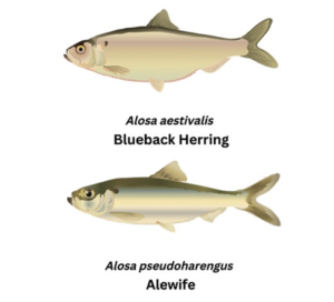
Figure 1: Two herring species utilize the Great Bay Estuary as they move throughout their life cycles. Data source: Integration and Application Network, University of Maryland, Center for Environmental Science
It’s spring and a new generation of river herring has hatched in the upper reaches of the Exeter River (1, see map below), the freshwater portion of what becomes the Squamscott River before it empties into the Great Bay. Only a few years ago, this leg of the journey would have been impossible, but with the removal of the Great Dam (2, see map below) in 2016, herring now have free run of the lower Exeter River for the first time in 400 years. These herring are actually two species of migratory fish: the blueback herring (Clupea aestivalis) and the alewife (Clupea pseudoharengus) (Figure 1). Later in the summer, the juvenile fish will swim toward the saltier waters of Great Bay, where they will seek cover and food in its salt marshes, intertidal rocky areas, eelgrass meadows, and oyster reefs. Those that survive will migrate to the Gulf of Maine, where they will live for approximately four years before returning to freshwater rivers like the Exeter to spawn and restart the cycle.
INTRODUCTION
In this story, you are invited to follow along with a juvenile river herring during its first few months of life from hatching in a freshwater river through its journey in the Great Bay and out to the Atlantic Ocean. This section is also a journey through the many challenges that threaten our watershed and two estuaries of national significance: Great Bay Estuary and Hampton-Seabrook Estuary. Be forewarned: the list of stressors is long! We list these stressors because we can not solve a problem if we do not accurately define what’s happening. Given the magnitude of these stressors, it’s the view of the Piscataqua Region scientific community that we must improve habitat quality using every tool we can control to compensate for factors we cannot control.
Science indicates that we can make a difference; indeed, we are making a difference. You will read about how nitrogen loading from point sources — “point source” refers to pollution that comes from an identifiable localized source, such as a wastewater treatment plant — is lower than at any other time in our data record. You will see that in some places, oysters are making a modest comeback. Data also indicate that migratory fish returns are higher than they’ve been since 1992. This is what it means to make a difference!
Help us continue to make a difference for our estuaries. Let your local government know you are concerned about the resilience of the Great Bay and Hampton-Seabrook Estuaries. This is the single most important thing you can do to protect these critical ecosystems! More specifically, here are some primary actions we can take together to build their resilience.
- Conserve land to preserve open space
- Maintain, adopt, and enforce riparian buffers (vegetated areas near streams and rivers)
- Manage stormwater to reduce pollution and flooding
- Better manage nutrient pollution from septic systems and wastewater treatment facilities
- Reduce your own contributions to pollution
More information on how to support these efforts is available in the State of Our Estuaries sub-publications: “Municipal Guide” and “Residential Guide.” With that, please take a deep breath and plunge into a journey through the Piscataqua Region Watershed!
FEWER HABITATS
![]() As the juvenile fishes make their way to the ocean where they will spend the next four to five years, they might encounter the beautiful and extensive salt marsh at Chapman’s Landing (3, see map below), where small mysid shrimp — one of their favorite foods — thrive. Before they enter Great Bay, they may spend some time in the Estuary’s largest oyster bed at the mouth of the Squamscott River, where there were over 4 million oysters in 2021! These shellfish provide safe places to hide from predators and plenty of food, such as barnacle larvae. From there, the young herring swim into Great Bay, where, at high tide, they take refuge in smaller fringing marshes, such as those in front of the Great Bay Discovery Center in Greenland, New Hampshire (4, see map below). At low tide, they leave the marsh edges in search of deeper water habitats, such as eelgrass beds, where shrimp are also plentiful, or they may venture to oyster beds near Nannie Island and Woodman Point in western Great Bay. The herring continue this tidal dance among habitats as they move through the estuary.
As the juvenile fishes make their way to the ocean where they will spend the next four to five years, they might encounter the beautiful and extensive salt marsh at Chapman’s Landing (3, see map below), where small mysid shrimp — one of their favorite foods — thrive. Before they enter Great Bay, they may spend some time in the Estuary’s largest oyster bed at the mouth of the Squamscott River, where there were over 4 million oysters in 2021! These shellfish provide safe places to hide from predators and plenty of food, such as barnacle larvae. From there, the young herring swim into Great Bay, where, at high tide, they take refuge in smaller fringing marshes, such as those in front of the Great Bay Discovery Center in Greenland, New Hampshire (4, see map below). At low tide, they leave the marsh edges in search of deeper water habitats, such as eelgrass beds, where shrimp are also plentiful, or they may venture to oyster beds near Nannie Island and Woodman Point in western Great Bay. The herring continue this tidal dance among habitats as they move through the estuary.
In the mid-1990s, young herring would have had a lot more habitat to use for food and shelter during their journey. While oysters and eelgrass still exist in the Great Bay Estuary, particularly south of Adams Point, they are far less abundant and healthy than they were 30 years ago. These days, the juvenile herring must spend more time moving across much larger stretches of bare estuary bottom where they are more vulnerable to predation. The story is the same for Little Bay and the Piscataqua River. Only 25 years ago, a young herring could travel from the eastern shores of Little Bay to the Piscataqua River and under the I-95 bridge in Portsmouth/Kittery, all the while remaining mostly under the cover of either eelgrass or oysters. Today, those habitats are greatly diminished and there are more extensive stretches of bare mud.
WARMER WATERS
![]() Throughout their journey, herring today are also swimming in warmer waters. An analysis of water temperatures taken in August at the Adams Point Station in Great Bay (5, see map below), where the time series goes back to 1988, shows a statistically significant warming trend through 2021. This is concerning since the warmest waters occur in August and September, which are the months when juvenile herring are beginning to move downstream. Warmer waters speed up the fishes’ metabolism, so they need more food to stay alive, increasing their reliance on food sources found in marshes, eelgrass beds, and oyster reefs.
Throughout their journey, herring today are also swimming in warmer waters. An analysis of water temperatures taken in August at the Adams Point Station in Great Bay (5, see map below), where the time series goes back to 1988, shows a statistically significant warming trend through 2021. This is concerning since the warmest waters occur in August and September, which are the months when juvenile herring are beginning to move downstream. Warmer waters speed up the fishes’ metabolism, so they need more food to stay alive, increasing their reliance on food sources found in marshes, eelgrass beds, and oyster reefs.
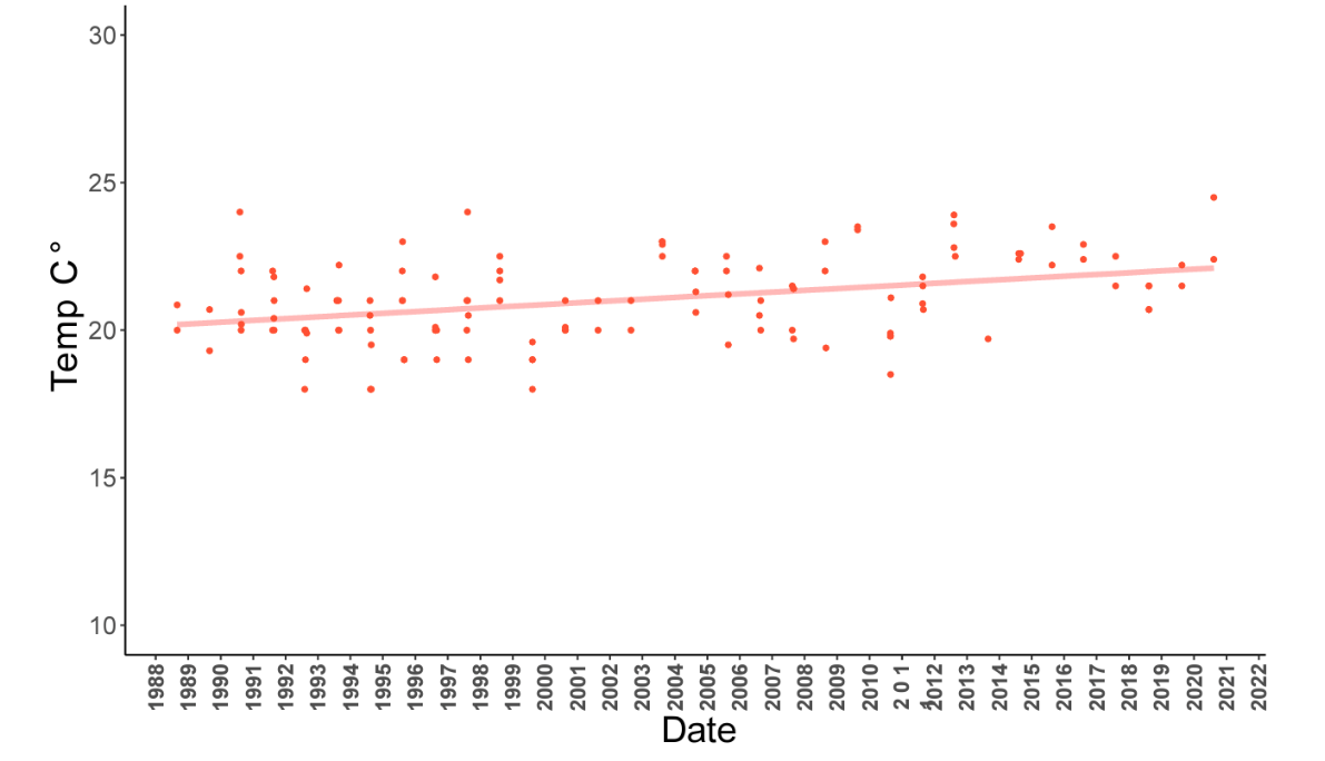
Figure 2: Water temperature taken at various tide stages at Adams Point Station during August, from 1988 to 2020. The increasing trend is statistically significant. Although the temperatures in this graph are below 25° C, temperatures in shallower areas, where eelgrass grows, are frequently above 25° C (see “Eelgrass”). Data source: Jackson Estuarine Laboratory, UNH
Higher water temperatures also adversely affect water quality. For example, certain harmful bacteria such as Vibrio species — which cause gastroenteritis and wound infections — are on the rise (see “Bacteria”). Warmer waters also nourish parasites that are reducing the lifespan of oysters in our estuaries. Finally, warmer waters impact eelgrass, another habitat on which juvenile river herring depend. In the warmest months, water temperatures in the shallow regions of Great Bay and Little Bay can rise above 25° C — that’s equal to 77° F — the threshold at which temperatures become harmful to eelgrass (Figure 2).
In general, science shows that temperatures higher than 23° C are less than optimal for eelgrass; temperatures as high as 25° C lead to considerable stress, and 28° C is lethal. Some research has found that six consecutive days over 25° C is enough to lead to eelgrass die-off. More data and discussion on water temperature and eelgrass can be found in the “Eelgrass” section of the report.
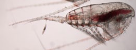
Even in the deeper waters of the Gulf of Maine, river herring will encounter waters warming faster than any place on the planet (see “Regional Perspective”). Herring population declines in the Gulf of Maine have been attributed to these warmer temperatures and shrinking populations of an important copepod, Calanus finmarchicus (Figure 3), a significant prey species for everything from herring to whales. But the story does not end when herring reach the Gulf of Maine. Their journey runs in reverse when herring reenter the Great Bay Estuary and make their way up the rivers to spawn. Once again, they are dependent on healthy waters and available habitat in order to create the next generation.
MURKIER WATERS
![]() The herrings’ journey is not only warmer, with fewer places of refuge, it’s also murkier. At Adams Point, on the border of Little Bay and Great Bay, data collected since 1988 show that concentrations of both total suspended solids and phytoplankton began to increase after the 1990s. It isn’t surprising then to see that light conditions have worsened over time (see “Light”) since total suspended solids and phytoplankton are the main factors that determine water clarity.
The herrings’ journey is not only warmer, with fewer places of refuge, it’s also murkier. At Adams Point, on the border of Little Bay and Great Bay, data collected since 1988 show that concentrations of both total suspended solids and phytoplankton began to increase after the 1990s. It isn’t surprising then to see that light conditions have worsened over time (see “Light”) since total suspended solids and phytoplankton are the main factors that determine water clarity.
Lower light is a problem for many organisms but especially for eelgrass. This problem becomes worse under higher water temperatures, which increases eelgrass’ metabolic rate. This means eelgrass plants require more photosynthesis and thus, more light when the water is warmer. Given that we have few tools, if any, to reduce water temperature, keeping waters clear takes on a greater importance.
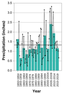
Figure 4: Extreme precipitation events. Black dots represent annual values, in some cases averaged over multiple stations. Green bars indicate averages for 5-year periods. Data source: adapted from NOAA Climate Summaries
STORMIER WATERS
 The young herring — and their habitats — will most likely experience a stormier estuary. If we look at extreme precipitation events since 1960 (Figure 4), we see that the Piscataqua Region Watershed is experiencing more of these events, a trend forecasters agree will continue.
More storms generate more runoff, washing more nutrients, sediments, and toxic contaminants off impervious surfaces and lawns into our estuaries — all of which negatively impact herring. As we consider our stormwater management strategies for the future, precipitation increases need to be part of our calculations.
RISING WATERS
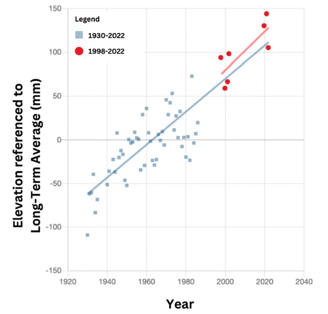
 Since 1998, sea levels have risen by over 2 mm a year and the rate is increasing. In our region, salt marsh is the habitat most impacted by sea-level rise (see “Salt Marsh”). But rising seas are eroding stream banks as well as marshes, increasing total suspended solids, and worsening light attenuation. This creates problems for herring, and also creates problems for humans who depend on salt marshes and other buffers for protection of their property from wave erosion and storm surge.
DOING WHAT WE CAN
With such significant physical changes occurring throughout our estuaries, protecting the herring of the future can seem like a daunting challenge. Stresses are increasing at a pace that could outstrip the slow recovery of estuarine habitats that support not only herring, but many other species and also our Piscataqua Region Watershed economy!
What can we do to protect the herring, their habitats, and the other benefits that healthy estuaries provide?
The solution is straightforward, though accomplishing it is difficult. We must improve water and habitat quality using everything we can control to compensate for factors that we cannot control. Things we cannot control include the changes we’ve made to the landscape that are difficult to undo; they also include stressors related to climate change (Figure 6). But we can control future changes in the landscape by developing in a more low-impact manner, reducing pollution through stormwater management and redevelopment, and conserving open space.
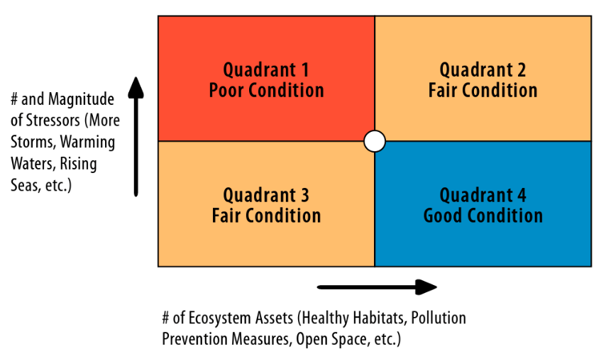
Figure 6: The Stressor - Asset Matrix breaks the condition of our estuaries into four quadrants based on the number and magnitude of stressors (vertical axis) and assets (horizontal axis). The white circle in the center is our hypothetical current position. To maintain our estuaries in “Fair” condition (Quadrant 2 or 3), we must either add to our assets or decrease stressors. The only way to reach Quadrant 4, which has “Good” condition, is to simultaneously increase assets and decrease stressors. Conceptual model: PREP
Success will be easier if we use a proactive rather than reactive approach. This strategy recognizes that even if we can reduce chronic stresses (e.g., pollution), the future could have episodic stresses (e.g., storms) in store for us. A proactive approach will result in estuaries that are both more resistant and more resilient to stress. Healthy estuaries — those in Quadrant 4 — are so well balanced that when a stressful condition arises, the reaction is seamless and we may not even notice (high resistance). And when healthy estuaries do experience a challenge such as a hurricane, they are able to bounce back (high resilience) when the stress is alleviated (Figure 7).
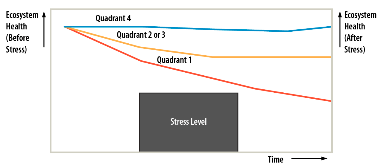
Figure 7: Conceptual model showing estuaries in different conditions reacting to stress. The Quadrant 4 Estuary (Good Condition) resists stress with very little change in health and returns to its original state when the stress is removed. Estuaries in Quadrants 2 or 3 (Fair Condition) are less able to resist stress and settle into a new, but less healthy, stable state when the stress stops. The Quadrant 1 Estuary (Poor Condition) is unable to resist stress, unable to improve its health, and experiences continued decline even when the stress is removed. Conceptual model: PREP
We all want our estuaries to be in Quadrant 4 of Figure 6, which represents “Good” condition. But climate change and the region’s increasing population are adding further stress on the system. Likewise, impervious cover, which contributes to increased nutrient loads, continued to increase 0.2% since 2015 (see “Impervious Cover”). Using the knowledge presented in this report we can make decisions that address these trends and improve the condition of our estuaries.
Around the watershed, work to turn the tide is happening. The Exeter Dam removal in 2016 is an excellent example of how a community can wrestle with difficult decisions and ultimately take action to decrease stress and add ecosystem assets. There are also actions underway like the major culvert restoration project near Rye Harbor that restore hydrology to impacted wetlands (Figure 8). Many communities around the region are implementing more effective stormwater management programs in their efforts to reduce nutrient loading and mitigate flooding.
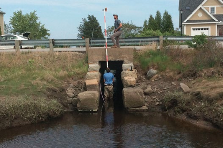
Figure 8: Surveyors plan a culvert restoration in Rye, NH, as part of the “Resilient Tidal Crossings” project. Designs call for this 3.5-ft wide culvert to be replaced in 2024 with a 15ft wide structure, restoring natural hydrology to critical salt marsh habitat on the Seacoast. Photo by Kevin Lucey
Initiatives like these provide support to our struggling habitats. Though the latest eelgrass data are mixed, there are some signs of recent improvement, such as new acres of eelgrass in the Portsmouth Harbor region. For the 21 years between 1999 and 2019, we had less than 5 million oysters in the Great Bay Estuary; we’ve had more than 5 million for the last two years for which we have data (see “Oysters”). In 2021, over 260,000 river herring returned to Piscataqua Region tributaries (see “Migratory Fish”); that number of returns has not occurred since 1992!
Scientists are often criticized — occasionally for good reason — for emphasizing what they do not know instead of what they do know. So let’s finish this story by emphasizing what we, the Piscataqua Region scientific community, do know. We know that our key habitats are struggling much more than we want them to be. We know that there are some signs that we could be having a positive impact on fish and shellfish and the habitats on which they rely. We know we have a long way to go to reach our goals, and we know that we have many continuing and newly emerging challenges. We know from attempts to restore other estuaries that recovery is possible and that it takes persistence and incredible effort.
The staff of PREP look forward to working with all of you to continue this huge but rewarding endeavor. For the river herring, for the other plants and animals in our estuaries, for our local economies, for all of us who enjoy clean water and abundant wildlife…let’s make sure that, in five years when the next State of Our Estuaries Report is issued, we can reflect on the benefits of another half decade of impressive work!
