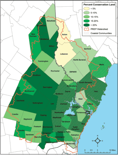
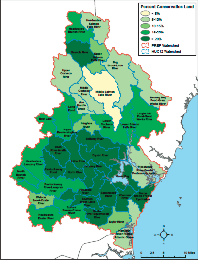
As of April 2022, 18.1% of the total land area in the Piscataqua Region Watershed (151,978 acres) was conserved. This represents an increase of 2.6% in new land area coming under conservation (21,676 acres) since the last report in 2017. Of the acreage considered conserved, 86% is under permanent protection. Across the 22 coastal communities in the region (those adjacent to tidal waters), a total of 56,907 acres of land has been conserved. This represents 22.3% of the total land area in those 22 towns.
In 2017, 28 communities had achieved greater than 15% of their land in conservation. As of 2022, six additional communities have conserved greater than 15% of their land area for a new total of 34 communities (Figure 5.1). Of those, 26 communities have met or exceeded the PREP goal of 20% of total acreage conserved. Overall, conservation lands have increased across most of the region. But there remain places where conservation lands, as a total percentage of the community’s land cover, are less than 5%. At the subwatershed level (HUC-12 analysis; Figure 5.2), areas where conservation efforts have been high (greater than 30% of total land area) include Branch River, Exeter-Squamscott, Great Bay, Lamprey River, Oyster River, Pawtuckaway Pond, and Scamen Brook-Little River. Conversely, areas where conserved lands lag include Bauneg Beg Pond-Great Works River, Bog Brook-Little River, Middle Cocheco River, and Middle Salmon Falls River.
Although land protection continues to progress, there is work to do to reach the PREP goal of conserving 20% of the land area. Land protection for the 22 coastal communities in the aggregate has exceeded 20%, but an additional 16,024 acres must be conserved to meet the 20% level for the entire watershed.

